Friday, December 2, 2022

Lines and Swirls Explained

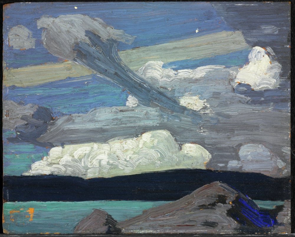
#2713 "Curly Hook Cirrus Sunset"
14x18 inches oils on canvas

As the world paves over paradise, may I suggest that you surround yourself with nature? The sky for doing so is the limit or so the saying goes. Actually, the sky has no limits for natural inspiration and perhaps I might be of some assistance. The sky is always available and all you need is time. 

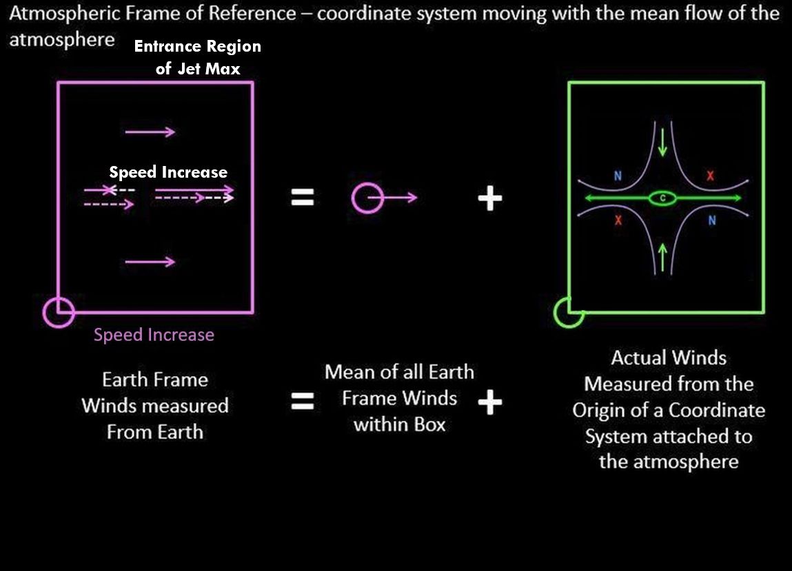
Start by watching the patterns move across the sky. The translation of the clouds does not have to impact the shapes. The average wind simply moves the clouds along. Without water vapour, the circulations are quite invisible but they are still there.  

Recall that moisture is shaped by relative motions within the atmospheric frame of reference. I have written about this many times but "Down to Earth Meteorology" is a good summary.  Absolute location to another reference frame such as the Earth only makes the patterns harder to comprehend. The shapes reveal the wind and those patterns are readily understandable in terms of lines and swirls. The answer is indeed blowing in the wind. Bob Dylan’s 1962 anthem posed some rhetorical questions about peace, war, and freedom and sixty years later, those elusive dreams have still not been attained. In the example of the atmospheric frame of reference, there is a solution though. All patterns within the atmospheric ocean evolve from that simple puff of wind along with smoke rings. 

I reiterated the foundation for this work in my previous blog, “A Jet Streak with a Paddle”. This current blog will assemble those parts in terms of lines and swirls. I will follow that with the easiest atmospheric example - mare’s tail cirrus.  After that, you are ready to understand every cloud in the free atmosphere – almost anyway. 

The Deformation Zone Conceptual Model complete with
Coriolis Hand Orientations - for reference looking down

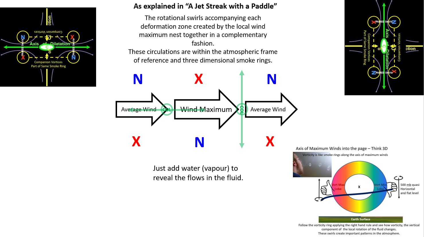
In “A Jet Streak with a Paddle” we established:

  • The col of the deformation zone (DZ) is located where the rate of speed increase or decrease is the strongest. 
  • The deformation zone (DZ) associated with a speed increase must parallel the flow.
  • The deformation zone (DZ) in an area of speed decrease must be perpendicular to the flow.

Looking Down as in a Satellite View


The Swirls of the Deformation Zone Conceptual Model 
can be added to the lines. You cannot have lines
without the swirls


Smoke Rings are the Three-Dimensional Manifestation
of the Local Wind Maximum. The Visible Smoke Ring
related to the Companion Swirls associated with the 
wind maximum

Cirrus cloud is almost always in the sky for our entertainment. Cirrus is much more exciting than most meteorologists give it credit for. This post and “A Jet Streak with a Paddle” will allow you to understand what the lofty cirrus has to say.

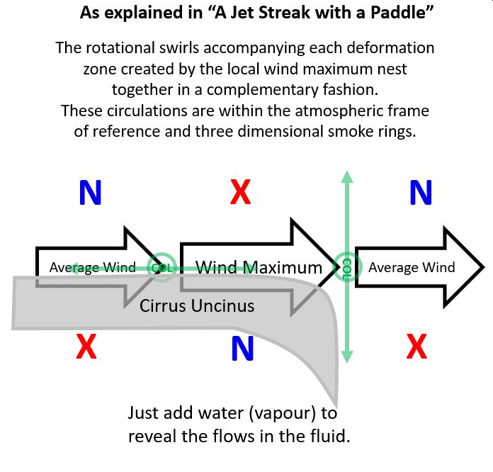
Cirrus uncinus is a special type of cirrus cloud. The word "uncinus" is derived from Latin, meaning "curly hooks". Also known as mares' tails, these clouds are generally sparse in the sky and very thin. The clouds occur at high altitudes, at a temperature of about −50 to −40 °C. They are generally seen when a warm or occluded front is approaching. They are also shaped by the relative wind!

The curl at the end of the band of cloud is associated with a decrease in wind speed. Within the atmospheric frame of reference, a decreasing wind speed requires deformation zones perpendicular to the direction of the flow. 
Looking Downward on the Curly Hook Cirrus Pattern
In order for the speed to decrease, somewhere upstream the wind must have increased in speed as compared to the average flow of the atmosphere. If the speed of the flow increases, the deformation zones must parallel the direction of the flow. The fingers of your Coriolis Hand when aligned with the curl of the cloud, reveals if the moisture is associated with the cyclonic or anticyclonic companions of the atmospheric flow. 

Typically moisture is found on the warm side of the jet stream. This corresponds to the anticyclonic companion. You might notice that the majority of the mare’s tails are anticyclonic swirls. The wind decreases at the end of each mare’s tail necessitating the axis of the deformation to align perpendicular to the flow.
Painting Looking Upward

You can also monitor the drift of the cloud by the average wind. Using your Coriolis Hand, you can determine if the drift relative to the average wind is either cyclonic or anticyclonic. Point the fingers of your Coriolis hand in the direction of the drift as you watch the approaching cloud.  If the drift is toward your left, your Coriolis thumb points downward and you are watching the anticyclonic companion of the deforming flow.  If the drift is toward your right, your Coriolis thumb points upward and the cyclonic companion is headed your way. Your right hand is your Coriolis Hand in the northern hemisphere. This is another application of the deformation zone conceptual model when the wind aloft is decreasing in speed. If there is no lateral drift in the cloud patterns, then the wind is increasing over you. I wrote about the Coriolis effect in "The Solution to Cloud Swirls Can Be Found in Your Hands". 

Everything begins with a change in wind speed. Everything! The change in wind speed results from a change in temperature which in turn drives the thermal wind which directly results in variations in wind speed. Meteorologists call this wind shear. Wind shear creates deformation zones and vortices but you can call them lines and swirls. It's OK, I do. 
Summary of the Lines and Swirls with a "Wind Maximum"
or Paddle Stroke complete with the orientation of your
Coriolis Hand revealing the sense of rotation remembering
of course that the circulation is really a 3D Smoke Ring in space
Looking Downward

Indeed, the entire Conveyor Belt Conceptual Model can be explained using these simple concepts. The infra-red satellite imagery was "fuzzy" in the 1980s but was still adequate to convince me of these truths based on my experience with the paddle. My artistic background was conducive to revealing the patterns I witnessed in the lake and translating them to what I saw in satellite imagery and the atmospheric ocean. The boundaries between air masses are more than just lines, they are deformation zones. 

There is only one thing you need to know - the local wind maximum is responsible for everything you will see in the sky. The wind maximum can be as large as a jet streak in the jet stream or as small as a gust of wind. All patterns in the free atmosphere can be explained by the local wind maximum which creates nested patterns of lines and swirls.

With thanks to my friend Dr. James Moore and
COMET who published many of my
meteorological musings. 

Warmest regards and keep your paddle in the water,

Phil the Forecaster Chadwick

Sunday, November 13, 2022

A Jet Streak with a Paddle

Empathy might be the most important character. We are not the centre of the universe. It is important if not vital to consider the other frame of reference. Walk a mile in their shoes and keep an open mind. Something that looks complex in your world can become exceedingly obvious in theirs. Take a jet streak or a paddle stroke in a lake for instance… 

One Must Examine Shapes in a Fluid from a 
A Frame of Reference attached to the Fluid
These thoughts and movies played out in my mind, typically on a night shift. The essential concept is that anything in a fluid is shaped solely by relative flows within that fluid. Any three-dimensional location with respect to anything else does not matter. The only frame of reference that needs to be applied is the one within the fluid. I have attempted on numerous occasions to explain this concept along with the following graphics. One memory from a classroom at COMET in Boulder, Colorado was disastrous. Everyone seemed so very confused... But I do not give up easily. 

The atmospheric frame of reference moves with the mean flow of the wind. The atmosphere is always in motion but those motions are not uniform around the globe. It is best to just consider a volume the size of a synoptic weather system. The absolute vorticity field can assist in identifying this but I will leave that for another day. 

In the accompanying graphics, the earth frame winds within the purple box are those measured from a given point attached to the globe. The average of all of these earth frame winds is the mean motion of the atmospheric frame of reference and the first term to the right of the mathematical "equals" sign. 

The winds as measured within the atmospheric frame of reference are those winds within the green box to the right. The relative winds within the atmospheric frame of reference shape the clouds that we observe. Mathematically, the vectors must add up and be identical on either side of the "equals" sign. 

The first graphic has calm winds within the atmospheric frame of reference. The cloud shapes must be simply translated across the landscape with the mean winds. 

No relative Motions within the Green Box of
the Atmospheric Frame of Reference

The next few graphics have a wind in the earth frame of reference that simply decreases a bit. Such a change solely in wind speed can be difficult to measure but the impacts on cloud shape are astounding. The result for me back in the early 1980s was the "Deformation Zone Conceptual Model" that Roger Weldon was talking about. A simple decrease in wind speed results in an obvious line perpendicular to the wind and four vorticity/swirl centres that are both paired across that line and companions on either side of the flow. I struggled to develop clear and concise terminology that was meaningful to meteorologists and the general public as well. The relative spins of these four vorticity/swirl centres control the shape of the line and reveal everything about the meteorology within that portion of the atmosphere. The rest of my meteorological career was defined by that single night shift. 

A Slight Decrease in the Wind Measured in the Earth Frame
of Reference Yields a Convergent Flow in the 
Atmospheric Frame of Reference. 

The Convergent Flow in the Atmospheric Frame of Reference 
becomes the Axis of Contraction in the Deformation Zone
Conceptual Model

Deformation Zone Conceptual Model

The next few graphics have a wind in the earth frame of reference that simply increases a bit. That pattern within the atmospheric frame of reference that develops is very different. A linear structure develops but it parallels the wind direction. The line is still a deformation zone but the conceptual model is rotated by 90 degrees. 
A Slight Increase in the Wind Measured in the Earth Frame
of Reference Yields a Divergent Flow in the 
Atmospheric Frame of Reference. 


The Divergent Flow in the Atmospheric Frame of Reference 
becomes the Axis of Dilatation in the Deformation Zone
Conceptual Model

Deformation Zone Conceptual Model

This leads me back to my first study of fluids and patterns which started with the family purchasing a fibreglass canoe around 1964. A single stroke of the paddle created a situation where the water increased in speed and then decreased while the canoe was propelled in the opposite direction - Newton's Third Law - for every action (force) in nature there is an equal and opposite reaction. The lines that I witnessed in the fluid frame of water were exactly the same as those within the atmospheric frame of reference. Duckweed is the canoeing equivalent of water vapour in the atmosphere. 
The Deformation Zone (DZ) Ahead of the Paddle Push
 is perpendicular to the Flow while
the DZ Behind the Paddle Push Parallels the Flow...
Intuitively Obvious if you are a Canoeist

An identical situation is also extremely important in the atmosphere - the jet streak or a local maximum in wind speed along the jet stream. Dr. James Moore provided the following conceptual model and graphic. I added the deformation zones. 


If the local wind speed is increasing, the deformation zone must parallel the flow. If the local wind speed is decreasing, the deformation zone must form perpendicular to the flow. The lines in any fluid form within that medium reveal everything to anyone who is willing to place themselves within the fluid frame of reference.

As a result, the observation of a deformation zone that is perpendicular to the flow requires that the flow is decreasing in that region of the atmosphere. A deformation zone that parallels the flow similar to baroclinic zone cirrus must be found in a region of the atmosphere where the flow is increasing. These are simple ideas but now you know how and why they work. 

As an illustration, applied to cirrus uncinusis. The name cirrus uncinus is derived from Latin, meaning "curly hooks". Also known as mares' tails, these clouds are generally sparse in the sky and very thin. The clouds occur at high altitudes, at a temperature of about −50 to −40 °C (−58 to −40 °F). The 
curl at the end of the band of cloud is associated with a decrease in wind speed. Within the atmospheric frame of reference, a decreasing wind speed requires deformation zones perpendicular to the direction of the flow. With moisture typically on the warm side of the jet stream which corresponds to the anticyclonic companion, you might notice that the majority of the mares tails are anticyclonic swirls.

Warmest regards and keep your paddle in the water,

Phil the Forecaster Chadwick

Wednesday, October 19, 2022

Tom Thomson Was A Weatherman - Summary As of Now

Thomas John Thomson (born 5 August 1877 in Claremont, ON;
died 8 July 1917, almost 40 years old )  circa 1905–10.                 
I started doing presentations about the art and science of Tom Thomson in the mid-1980s. I did not keep count but the number of presentations certainly numbers in the hundreds. This mountain of material has grown into a book that is now being blogged a bit at a time. 

Thoreau MacDonald (1901-1989), the son of JEH MacDonald of the Group of Seven, was also a friend of Tom and he wrote:

Thomson’s work would be a fine study for some competent critic, but anyone attempting it should be familiar, not only with every phase of his work but with the country too, lakes, rivers, weather; have them in his bones …

I prefer to be positive... being critical is not my style but my natural science background might bring fresh information to the Tom Thomson catalogue raisonnĂ©. This project will take some years to complete but I am in no rush. 

In the draft of my "Tom Thomson Was A Weatherman" book, I included several chapters describing the meteorology and natural science employed to better understand his art. This information has already been written in the "The Art and Science of Phil the Forecaster" blogs which I have been compiling for many years. If you should encounter a term or concept that I do not adequately explain within the context of a particular Thomson work, a search of this site will certainly yield the answers. I will typically include linked references to the required background information with each painting. 

The following is a list of the Blog entries to date accompanied by a representative image and a linked title to the Blog. Some paintings require more than one blog to fully explain. Tom accurately painted the truth of what he saw. 

Arthur Lismer, his friend and Group of Seven member described Thomson as someone who "sought the wilderness, never seeking to tame it, but only to draw from it, its magic of tangle and season." That wilderness put the "wild" into his art. 

Blodwen Davies included in the 1967 publication "Tom Thomson: The Story of a Man Who Looked for Beauty and for Truth In The Wilderness" that  Tom Thomson had remarked: "Someday they will know what I mean." Hopefully, that day has arrived.

Note: Miss Blodwen Davies's passed in 1966 but she had previously sought help from Group of Seven artist A. Y. Jackson, who had written the Foreword to the first self-published version in 1935. That first printing was limited to 100 copies and the 1967 republished version of that scarce book is available to a larger audience. 

Thank you for your interest. These posts have been a lifetime in coming. 

Tom Thomson Was A Weatherman


Tom’s Tornado!


Tom’s Tornado Two - Some Science

Tom’s Tornado Three - Some Art


Tom's Summer Clouds


Thunderhead: Pink Cloud over a Lake - Summer 1916


Lightning, Canoe Lake: Summer 1915


Tom Thomson’s Last Weather Observation


Tom Thomson's "A Northern Lake" Was the Belt of Venus Sunrise
Tom Thomson's Black Spruce Autumn 1915 observation of a cold frontal passage
Tom Thomson's "First Snow in Autumn", Fall 1916 - Light and fluffy snowsquall snow laden on drooping balsam fir branches


Tom Thomson's Approaching Snowstorm - actually a snowsquall as contrasted with a synoptic scale winter storm.
Tom Thomson's After the Sleet Storm, 1916 - published 25 years after the 1998 Ice Storm and it brings back many personal memories.
Tom Thomson's Burnt Land at Sunset - the dynamics of the weather was Tom's inspiration. 


Tom Thomson's Afternoon: Algonquin Park, 1915 Studio Work in The Shack - Tom painted this in late November 1914 and one of his last works in the Studio Building before heading to the Shack. 

Tom Thomson's The Morning Cloud, 1913 Plein air sketch from the autumn of 1913. What an unusual cloud!

Tom Thomson's Petawawa Gorges Night 1916. The "fallout" from Creative Scene Investigation requires that "Petawawa Gorges, Night" along with the alternate titles "Sunset behind Cliff" and the "The Coming of the Night" need to be revised. The reality is that Thomson was a morning person and this painting was certainly a sunrise observation of light and shapes.


Islands, Canoe Lake, 1916. Some interesting meteorology and history. Tom Thomson spent some time at Canoe Lake in October 1916 after spending the summer being a forest fire ranger at Achray on Grand Lake. 

Landscape with Snow, 1916. Even more interesting meteorology and history. The flip side of Tom Thomson's “Rising Mist - Heavy Skies” Autumn 1916

Smoke Lake - Summer 1915. This is another of Thomson's double-sided panels and there is a story of weather and confusion behind it. 
The flip side of Northern Lights 1915.

Northern Lights 1915. The flip side of Smoke Lake - Summer 1915. Tom observed and recorded space weather as well. 

Path Behind Mowat Lodge, Spring 1917, The gift to Daphne Crombie includes a lot of interesting science as well. 
Canoe Lake Spring, 1917 - an afternoon sketch with the centre of the low-pressure area nearby turns into much more with the assistance of Roy MacGregor
Moonlight Over Canoe Lake 1916 A tremendous amount of science in this plein air panel...
Sunset Spring 1916 ... the view may not be what you think it is! 
Spring Sunset, Algonquin Park Spring 1916 also holds some surprises... this story was never told.
The Marsh, Early Spring 1916 - a challenge to place the location but not in the weather.


Sunset, Summer 1915. There is a lot of science in this painting and it was a spring sunrise (not sunset) painted around May 24th, 1915...

Sunset Sky, Summer 1915 was indeed a sunset but was observed in the spring.  
Sunset Sky, Spring 1915 was a spring painting but was actually a sunrise. This post has been years in the making and I have never included it in a “Tom Thomson was a Weatherman “ presentation. The last two posts lead to this one - a trio if not a quartet of skyscapes within a single event. 


Morning, Algonquin Park, Spring 1915. It was a dark and stormy morning at Canoe Lake that spring morning in 1915 when a cold front was crossing Mowat.
Ragged Pine, Spring 1916. Actually a black spruce but that is only the tip of the true story. 

Rocky Shore and Sky Summer 1915  The foreground was the devasted shore of Canoe Lake left behind by the forest industry.. lost habitats. The sky was full of interesting science!


Hot Summer Moonlight Summer 1915. Actually, a view overlooking Grand Lake from Achray possibly at 9 pm on May 11th, 1916... The waxing quarter moon spread the glow over the choppy waters of Grand Lake while a spring storm approached. And the story was recorded in Tom's brushstrokes. 

Sunset by Lake Alternate title: Sunset Summer 1915 Quite the back story behind this painting... 
Blue Clouds, Wooded Hills, and Marshes Summer 1915. Science Tuesday shines a new light on this painting... perhaps from 1916. 
Stormy Sky Summer 1915. Actually a split cold front mid-morning in spring. 
Fire-Swept Hills Summer or Fall 1915. Long-range Forecast: Continuing hot and dry for the rest of the 21st "Century of Fire". 


Ragged Lake Alternate titles: Northern Lake; Ragged Creek Fall 1915
Autumn Clouds Fall 1915 Dynamic cloud shaped by the wind bathed in the light of sunset tell an intriguing story of science and the weather.
Evening Cloud Alternate titles: Evening Clouds; Storm Cloud; Storm Clouds Fall 1915 Hers is the real story... cumulus congestus at a cold frontal passage wearing the Belt of Venus...

Artist's Camp, Canoe Lake, Algonquin Park Alternate title: Night Camp Fall 1915. There is a very interesting story behind the white "balloon silk", state-of-the-art tent. 
Tea Lake Dam Fall 1915 certainly painted in the spring with logs going to market - probably 1916. 
Moonlight Fall 1915 Actually painted in the spring of 1916... on the evening of April 18th about 18 hours before Ragged Pine, Spring 1916.
Abandoned Logs Fall 1915 Those logs were not abandoned in the spring of 1916 when Tom observed the log drive along Carcajou Creek. The tall pile of logs was a landing piled high by the hard-working lumbermen. 
Sketch for "The Drive" Fall 1916 After painting Abandoned Logs Tom probably strolled 100 metres along the western bank of Carcajou Creek to were the lumbermen were actively guiding logs through the sluiceway of the dam on the May morning in 1916. 
Sandbank with Logs, Summer or fall 1916  There is actually quite an interesting story behind this tangle of timbers... 
Bateaux Summer 1916 Actually Pointers and there is quite a story to be told. 


Yellow Sunset, Spring or Summer 1916 There are two sides to this very interesting story!


View from the Top of a Hill 1916. This is the flip side of "Yellow Sunset".  Together they tell quite a story. 

Aura Lee Lake Spring 1916

Phantom Tent Alternate title: Wood Interior Fall 1915
Tamaracks Alternate titles: Purple Distance; Yellow Trees Fall 1915
Tamarack Swamp Alternate title: Tamarack Fall 1915 
Round Lake, Mud Bay Alternate title: Geese, Round Lake, Mud Bay Fall 1915
November Day Alternate title: A November Day Fall 1915 
Sunset, Canoe Lake Alternate title: Canoe Lake Fall 1915
Northern Lake Alternate title: Northern Lake, Spring Summer 1916 
Poplars by a Lake Alternate title: Lake Through Trees Summer or fall 1916 
The Dead Pine Alternate title: Lone Pine Fall 1916 
Petawawa Gorges Alternate titles: Cliff Landscape; Storm Over River Fall 1916
View from a Height, Algonquin Park Fall 1916
The Lake, Bright Day Fall 1916 

Somber Day Fall 1916 
Ragged Pine Fall 1916 
Birch by a Lake, with Big Cloud Alternate titles: Birch by a Lake; Birches; Clouds over a Lake Fall 1916 
Autumn, Algonquin Park 1916
Lake in Autumn Alternate titles: Late Afternoon?; Swamp in Fall? Fall 1916 
Canoe Lake, Algonquin Park Fall 1916
Pink Clouds Fall 1916
Wild Geese: Sketch for "Chill November" Alternate titles: First Snow Ducks; Sketch for "Chill November" Fall 1916 
Sunset, Canoe Lake Fall 1916


The ability of nature to inspire can be magical. The preceding articles were never intended to teach the incredible complexities of physics or meteorology. The goal was simply to inspire the reader to look at the natural world from a fresh perspective - to appreciate the magic of nature and perhaps become a "weather walker" and a protector of the environment. 

Tom was inspired by the super-natural that he witnessed through his brief forty years. That world is being threatened by unsustainable consumption which is the source of all environmental issues. The reader inspired by Tom's art and nature might be moved to take action for future generations as we careen through the Sixth Mass Extinction and  Earth's Loss of Biodiversity. That was the other goal of this effort disguised as art history. Art and science can be compatible. 

Of course, you may simply wish to enjoy the art of Tom Thomson and that is absolutely fine as well - even encouraged! As Claude Monet said: “Everyone discusses my art and pretends to understand, as if it were necessary to understand, when it is simply necessary to love.”

I always left the last word for Tom Thomson at the end of every "Tom Thomson Was A Weatherman" presentation. On Saturday, July 7th, 1917 the day before he died, Tom wrote to his patron Dr. James MacCallum: "Will send my winter sketches down in a day or two and have every intention of making some more..." Tom was not finished his artistic journey!

There are many more articles to come but it takes time to translate the "Tom Thomson Was A Weatherman" book into blogs .. and I still need to follow my own artistic journey -  and catalogue raisonnĂ© as well. I prefer to tell my own story so that any mistakes are my own. 

Warmest regards and keep your paddle in the water,

Phil the Forecaster Chadwick

PS: I once corresponded with Ross King, the author of "Defiant Spirits" and he wrote: considering the "ancient question of St. Hilary of Poitiers—“Who can look on nature and not see God? ”—can be given a Canadian twist. Who can look on nature and not see Tom Thomson?" That phrase does indeed sum up the art and science of Tom Thomson.