 |
| #2277 "Singleton Summer Clouds" |
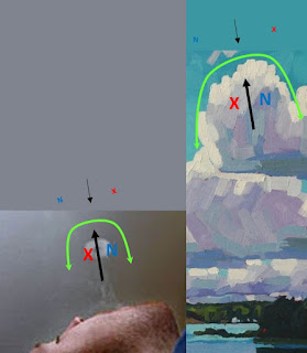
I watched a buoyant cumulus rising in the spring sunshine. It reminded me that it was time for the next instalment in weather appreciation. Give me a swirl, and I will give you a line and three more swirls. Or give me a line and I will return the favour with four swirls. The weather is lyrical and understanding what those swirls and lines are saying is real meteorology. Weather is not a battle; weather is more like a ballet of forces and physics. All you need is your imagination and your right hand (for the northern hemisphere, but use your left hand if you are south of the equator).
I typically see the lines first before swirls. The lines are boundaries between different air characteristics. One side of the line is probably warmer and more moist. The cloud elements can be witnessed as wonderful tracers of motion while the other side is cooler and drier and cloud free. The lines control the weather and they are easily understood. These lines are also created in the atmospheric frame of reference. Our 2D conceptual model is still informative regarding the processes and shapes in the 3D world of the smoke rings - but much simpler to describe in a planar world.
 |
| The Deformation Zone (DZ) Conceptual Model of Two opposing Puffs along the Axis of Contraction ; The DZ Line and the The Four Swirls |
The atmospheric environment is rarely in balance. Heat, moisture, electrical charge and a host of other quantities are always being transported up and down and north and south to try to keep the earth in harmony.
Now imagine that the puff of air that generates the smoke ring is unbalanced and strong and directed toward the deformation zone. The strong puff generates intense, adjacent, companion swirls. The angular momentum of the strong swirls of the smoke ring is a conservative property that only decay with turbulence and time. The meteorological horizontal cross section reveals companion vorticities of the same strength bordering the strong puff. I use larger fonts to depict more intense vorticity swirls.
The confluent asymptotes that stretch outward from the col can be no longer straight. The confluent asymptote bordering the cyclonic swirl must curl cyclonically. The companion anticyclonic confluent asymptote bordering the anticyclonic swirl must be curled anticyclonically. The new deformation zone comprised of these two confluent asymptotes joined at the col, resembles a drawn bow that is pulled and releasing the strong puff of air. The air and weather system are moving in the direction shot by the bow. The strong swirls can be easily understood in 3D by using the appropriate hand.
The effects of the strong puff also impact the meteorology on the opposite side of the deformation zone. As the cyclonic confluent asymptote becomes more cyclonically curved, the paired anticyclonic swirl across the DZ finds itself in a larger volume of air. Like a figure skater extending their arms, the rate of rotation for that “N” decreases even while the angular momentum remains conservative and unchanged. An identical process happens simultaneously with the paired cyclonic swirl, the red "X".
As those two swirls slow their rate of rotation, the inflow puff between them must also slow. A change in just one element of the deformation zone conceptual model is communicated to every other element and changes everything! In addition, these principles apply at all scales of motion from the microscopic to the cosmic. The creative human can watch these patterns unfold in the sky and really understand.
A 2 dimensional look at the changing deformation zone is sufficient to explain what happens in 3D. My friends in COMET created straw-dog animations of some of these principles, many years ago (2006 and 2007). This material was well outside my official duties but I felt it was important to get these concepts documented from night shifts many years previous. The COMET animator was gifted and gifted me with these representations of mind-wanderings free from daily distractions. I wanted to illustrate how a change in any single component of the DZ conceptual model is communicated to influence the other components.swirls) and warmest regards,


No comments:
Post a Comment