Monday, May 31, 2021

Dancing with the Weather

#1717 "Sunset Waves Nite"

The last couple of years of meteorological blogs can be summarized by creative, body movements – the Weather Dance. I failed at making this mainstream meteorology during my career but I do not give up easily. Perhaps this meteorological approach was too much fun?  I believe that your career should be your passion and that it must be creative and fun. A career can last a lifetime so you might as well enjoy it. You gotta laugh! By using only your Coriolis Hand and the attached arm, we can better understand the conceptual models that depict the Atmospheric Conveyor Belts, the Deformation Zone and even Thermal Advection. I call this approach "Dancing with the Weather". 

The weather is more of a ballet than a battle anyway... Weather is a balancing act that moves forms of energy all around the Globe in order to keep the earth in balance. Sometimes these motions are focussed, magnified and intensely damaging as a result. Supercellular thunderstorms, tornadoes and tropical storms come to mind. Everyone wants to see a tornado before they die... but not just before they die. I have used this line many times during my presentations and never get tired of casting out that hook.  Humans see this extreme weather as break dancing... literally. But all weather dances serve a purpose in moving energy around.

Conveyor Belt Conceptual Model (CBCM)

The Conveyor Belt Conceptual Model (CBCM) is a vital tool required to better understand the weather. Warm air rises as it is moved northward along the isentropic surfaces. Cold air sinks as it is advected toward the south. Water vapour and electrical charge are also added into the mix to make the weather.  This essential conceptual model also employs the deformation zone and thermal advection concepts. If you follow this train of thought to the end of this blog, you are on your way to really understanding the weather around you. 

For a start ... focus on your Coriolis Hand and the attached arm. This is your right hand if you are in the Northern Hemisphere and your left appendage if you are south of the equator (see  “The Solution to Cloud Swirls Can Be Found in Your Hands”). 

Coriolis Hand with
Thumb Pointing Up
If your Coriolis Thumb is pointing upward, your Coriolis arm is oriented like the cyclonic companion of the warm conveyor belt (WCB) of the CBCM. Your elbow will even bend cyclonically. What does this mean for the weather you can expect with the cyclonic companion? The answer is more weather with ascending, moist air. Embedded convection is also likely along the cold front. The following Radar Palette material was initially presented in "The Cold Conveyor Belt - The Weather Wizard Behind the Curtain". The Radar Palette did not get published but it is the equivalent to the Satellite Palette using conventional, Doppler and dual polarized radar to investigate the conceptual models of the atmosphere. 

Weather with the Rising Cyclonic Companion of the WCB


Coriolis Hand withThumb Pointing  Down
If your Coriolis Thumb is pointing down, your Coriolis arm is oriented like the anticyclonic companion of the WCB of the CBCM. Your arm will feel twisted and uncomfortable while in this orientation. Your elbow will not bend comfortably in the anticyclonic direction. The weather with the anticyclonic companion is drier with descending air. 
Weather with the Anticyclonic Companion of the WCB

The Warm Conveyor Belt (WCB) of the Conveyor Belt Conceptual Model (CBCM) is composed on both the cyclonic and anticyclonic companions. Each have their own characteristics as described which define the associated weather. 

The Dry (DCB) and Cold (CCB) conveyor belts are also composed of cyclonic and anticyclonic companions so there are at least six Coriolis arms in the ballet of each and every weather system. These flows would also be shifting with the differential thermal advections as described in "Shifting Winds? Why?". Even the most complex weather situation can be displayed and understood using your Coriolis Arm.  

Imagine the weather dancing going on especially on night shifts, trying to explain the weather patterns witnessed on the satellite imagery. The remote sensing information like satellite and radar revealed the real atmosphere and the actual weather. Trying to explain the Weather Dance was fun, funny and illuminating all at the same time. The following two collages of images are all you really need to remember so that you might better understand the atmosphere and the weather that you witness. 

Cyclonic Coriolis Arm (red for cyclonic)


Anticyclonic Coriolis Arm  (blue for anticyclonic) 

By employing the Conveyor Belt Conceptual Model and your Coriolis Hand,  you can examine and understand the three dimensional nature of the clouds and how they fit together in time and space. It helps if you know which way is north (for the slope of the isentropic surfaces that the conveyor belts follow) but really, you just need to know up from down...

Keep you paddle in the water and warmest regards... stay safe, 

Phil the Forecaster Chadwick
PS... More to come. 

Wednesday, May 26, 2021

Warming Winds and Deformation Zones


#1906 "Sunrise Freezing Rain Deformation Zone"  
Looking East

Sometimes it is best just to enjoy and paint the weather. I often do only that. The above painting includes gravity waves and deformation zone chains along a warm conveyor belt but I was focussed more on the shapes and the colours. I painted what I saw. Each line does indeed tell a story but it can get complicated even using your Coriolis Hand. You need to know which way is north and which lines are the regular gravity waves perpendicular to the wind and which are confluent asymptotes paralleling the atmospheric frame flows. This will not be on any exam... just enjoy the weather and the beauty of nature.  As described in "The Nature Fix" by Florence Williams (2018), it is good your you. The science is always easier from the bird's eye satellite view of the weather. 

The previous two blogs about thermal advections and dynamically changing the shape of the deformation zone, have been a bit heavy for light reading. The posts developed these conceptual models from first principles using only your Coriolis Hand, your imagination and thought experiments. That is exactly how they were developed on night shifts in the weather centre. The mental images playing in my mind where the same in the satellite imagery that I was using to discover the forecast problem of the day.

Warming wind shear and the double-cyclonic deformation zone pattern are probably the most important concepts to weather watchers. Warm and moist air being moved northward is the source of the weather that we observe and forecast in the mid and higher latitudes. The graphic for the idealized, double-cyclonic deformation zone chain was made by my COMET friends in Boulder, Colorado. This two dimensional graphic does a pretty good job at portraying what happens in the actual three dimensional atmosphere. Remember that with a warming wind, only the cyclonic swirls are enhanced. 


A chain of deformation zones can be quickly sketched between a series of vorticity maxima (cyclonic swirls and the red "X's") along a channeled jet. As a result of the wave nature of the atmosphere, subtle vorticity maxima can be inferred at regular intervals even if the corresponding satellite signature is inconclusive. 

Vorticity maxima chains are typically located between the bottom of the upper trough and the downstream point of inflection (the black circle in the following graphic) where the cyclonic curvature of the trough changes to the anticyclonic curvature of the downstream ridge. Analysis of these chains is best achieved by locating poleward "bumps" in the axis of maximum winds and the cloud patterns. The lines of moisture will reveal "backward s" shaped deformation zones between the vorticity maxima in the chain. 


The satellite example was from 2003 but such a pattern happens almost every day. Your Coriolis Hand with your thumb pointing upward at every red “X” will reveal the sense of the rotation. If you are looking for weather, be it enhanced cloud or precipitation, look just downstream from each red “X” which move at about a half of the speed of the atmospheric winds – typically toward the northeast. 

Every line in the sky has a tale to tell. I spent countless hours deciphering what the atmosphere had to say and I am happy to share those stories here.  

Keep you paddle in the water and warmest regards... stay safe, 

Phil the Forecaster Chadwick


Monday, May 10, 2021

Cloud Edge Shapes - The "Backward S" Deformation Zone

#2065 "Summer Cirrus" (Singleton Lake, Ontario)

What does it mean if a shifting wind veers? A more global visualization is to take your meteorological Coriolis force hand and point your thumb down. I will explain...

Coriolis Hand with Thumbs Down
Warm Advection
That magical Coriolis appendage is your right hand if you live in the Northern Hemisphere and your left hand if you are down under, south of the equator.  The thumb of your Coriolis hand pointing down, will force your fingers to curl in the same direction as wind shear resulting from warm air advection. The following examples will be for the northern hemisphere as that is where I live and paint. I will try to use the more Global phrase “warming wind” instead of the more nautical and historical term "veering". 

To watch the warming wind veer, implies that the wind shift occurs over a period of time. Historically and mathematically, meteorologists have only considered what is happening when winds veer with height. The answer to both questions is that warm air is being advected by a veering wind, whether that change occurs in space or time. 

Wind Veering with Time Moves Warm Air Northward


Companion Swirls straddle the inflows
Paired Swirls see each other are across the DZ
What impact does a warming wind have on our deformation zone (DZ) conceptual model. Let’s start with the simple straight line DZ. The DZ Conceptual Model is a dynamic concept and how it changes, reveals the weather. The following graphics describe the cause and effect of how the changes in just one component of the DZ Conceptual Model is communicated to the other nine components. It takes longer to explain while the atmosphere does all of this instantaneously. These changes just come naturally. 

The only physical law that we need to apply is the conservation of angular momentum. Figure skaters conserve angular momentum all of the time. Their rate of rotation increases as they draw their body inward to a tight spindle. These same skaters slow their rotation by extending their arms and legs outward. 

Shifting inflow winds along the axis of contraction toward the DZ must impact on the shape of that DZ! As I described in “Lines and Swirls in an Unbalanced Atmosphere” a change in any one of the components of the DZ conceptual model, must be communicated to them all.

What happens to the companion swirls that border the veering wind of one of the inflows to the DZ? The cyclonic companion occupies a smaller volume while the area of anticyclonic companion simultaneously expands. I always associated the font size with the intensity or speed of the swirl  rotation. As a result the red “X” must spin faster in the smaller volume and the font size increases. The blue “N” rotates slower in the larger area and the font size decreases. The total amount of angular momentum remains unchanged for the two swirls just like for a figure skater. 

The “backward-S” DZ

The confluent asymptote adjacent to the big spinning red “X” must curl more cyclonically. The confluent asymptote adjacent to the small blue “N” must curl less anticyclonically - which is the same as saying that the confluent asymptote must curl more cyclonically. Both confluent asymptotes must curl more cyclonically relative to their red "X" swirls. Together these two confluent asymptotes are joined at the “col” to construct a single “backward-S” shaped deformation zone. 

Simultaneously the paired swirls across the confluent asymptotes must respond to the changes induced by the veering inflow. As the red X's spin faster in the smaller volumes and become larger fonts, their paired blue N's must spin slower in their enlarged areas and become smaller. There are many different ways to think about this but the result is always the same. 

The end result in a warming wind shear is a double-cyclonic deformation zone.  Both confluent asymptotes stretching outward from the col are shaped cyclonically and the red X's dominate the pattern. Simply, if the cloud lines are shaped by cyclonic swirls, the atmosphere is warming. 

In the northern hemisphere, a double-cyclonic swirl deformation zone must be shaped like a "backward S" which is the term I used in the 1990's when I first started to describe these concepts. South of the equator a double-cyclonic swirl deformation zone is shaped like an "S". I employed these ideas when I was the meteorological support for the Solar Car Race across the Australian Outback in 1996. I was not successful in explaining those concepts then either…

I played these thought experiments in my mind mainly on night shifts. The words played out like a movie in my mind’s eye. The wonderful thing is that the very same show was being played in the satellite loop of the real atmosphere... which was also my forecast concern of the day.


Double-cyclonic Deformation Zone Chain

Here are the take home concepts my weather friends. When do winds veer in the northern hemisphere atmosphere? Warm advection. Where can you find warm advection? When winds blow from the warm southern latitudes toward the pole. In the northern hemisphere that means southerly winds advect warm air toward the north and winds tend to veer with height... and with time. Lines of cloud must be shaped like backward S's or double-cyclonic deformation zones which is the terminology that I prefer. 

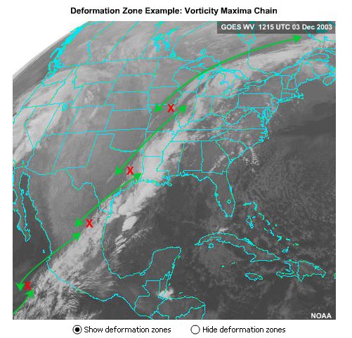
In #2065 "Summer Cirrus" (Singleton Lake, Ontario), the long lines of clouds whether they be a gravity wave or a Langmuir streak have a gentle double-cyclonic shape. Use your Coriolis Hand and point your thumb upward for a cyclonic swirl and you can see that the lines of clouds are a chain of double-cyclonic deformation zones as depicted in the above graphic produced by my COMET friends in Boulder, Colorado. The warming wind was over Singleton Lake on that summer day - and that is part of the story behind that painting.  

More on this in the next entry. Keep you paddle in the water and warmest regards... stay safe, 

Phil the Forecaster Chadwick