Empathy might be the most important character. We are not the centre of the universe. It is important if not vital to consider the other frame of reference. Walk a mile in their shoes and keep an open mind. Something that looks complex in your world can become exceedingly obvious in theirs. Take a jet streak or a paddle stroke in a lake for instance…
 |
One Must Examine Shapes in a Fluid from a
A Frame of Reference attached to the Fluid |
These thoughts and movies played out in my mind, typically on a night shift. The essential concept is that anything in a fluid is shaped solely by relative flows within that fluid. Any three-dimensional location with respect to anything else does not matter. The only frame of reference that needs to be applied is the one within the fluid. I have attempted on numerous occasions to explain this concept along with the following graphics. One memory from a classroom at COMET in Boulder, Colorado was disastrous. Everyone seemed so very confused... But I do not give up easily.
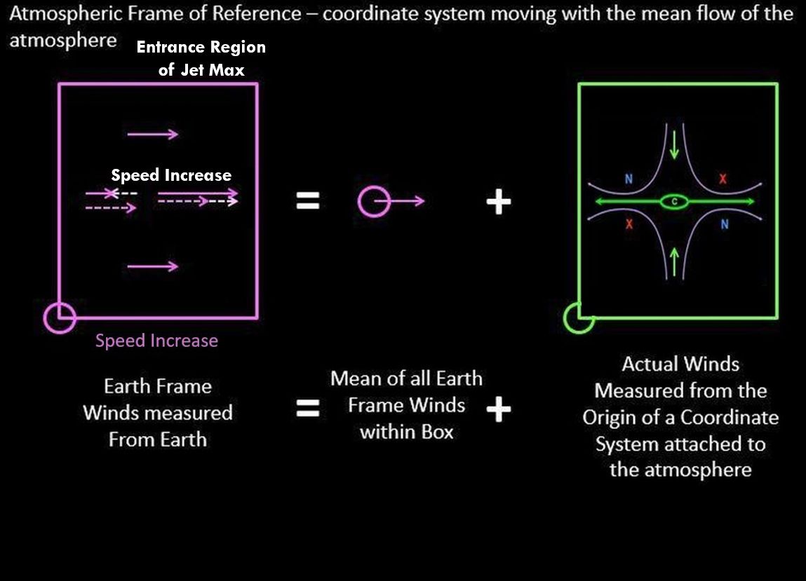
The atmospheric frame of reference moves with the mean flow of the wind. The atmosphere is always in motion but those motions are not uniform around the globe. It is best to just consider a volume the size of a synoptic weather system. The absolute vorticity field can assist in identifying this but I will leave that for another day.
In the accompanying graphics, the earth frame winds within the purple box are those measured from a given point attached to the globe. The average of all of these earth frame winds is the mean motion of the atmospheric frame of reference and the first term to the right of the mathematical "equals" sign.
The winds as measured within the atmospheric frame of reference are those winds within the green box to the right. The relative winds within the atmospheric frame of reference shape the clouds that we observe. Mathematically, the vectors must add up and be identical on either side of the "equals" sign.
The first graphic has calm winds within the atmospheric frame of reference. The cloud shapes must be simply translated across the landscape with the mean winds.
 |
No relative Motions within the Green Box of
the Atmospheric Frame of Reference |
The next few graphics have a wind in the earth frame of reference that simply decreases a bit. Such a change solely in wind speed can be difficult to measure but the impacts on cloud shape are astounding. The result for me back in the early 1980s was the "Deformation Zone Conceptual Model" that Roger Weldon was talking about. A simple decrease in wind speed results in an obvious line perpendicular to the wind and four vorticity/swirl centres that are both paired across that line and companions on either side of the flow. I struggled to develop clear and concise terminology that was meaningful to meteorologists and the general public as well. The relative spins of these four vorticity/swirl centres control the shape of the line and reveal everything about the meteorology within that portion of the atmosphere. The rest of my meteorological career was defined by that single night shift.
 |
A Slight Decrease in the Wind Measured in the Earth Frame
of Reference Yields a Convergent Flow in the
Atmospheric Frame of Reference. |
 |
The Convergent Flow in the Atmospheric Frame of Reference
becomes the Axis of Contraction in the Deformation Zone
Conceptual Model |
 |
| Deformation Zone Conceptual Model |
The next few graphics have a wind in the earth frame of reference that simply increases a bit. That pattern within the atmospheric frame of reference that develops is very different. A linear structure develops but it parallels the wind direction. The line is still a deformation zone but the conceptual model is rotated by 90 degrees.
 |
A Slight Increase in the Wind Measured in the Earth Frame
of Reference Yields a Divergent Flow in the
Atmospheric Frame of Reference. |
 |
The Divergent Flow in the Atmospheric Frame of Reference
becomes the Axis of Dilatation in the Deformation Zone
Conceptual Model |
 |
| Deformation Zone Conceptual Model |
This leads me back to my first study of fluids and patterns which started with the family purchasing a fibreglass canoe around 1964. A single stroke of the paddle created a situation where the water increased in speed and then decreased while the canoe was propelled in the opposite direction - Newton's Third Law - for every action (force) in nature there is an equal and opposite reaction. The lines that I witnessed in the fluid frame of water were exactly the same as those within the atmospheric frame of reference. Duckweed is the canoeing equivalent of water vapour in the atmosphere.
 |
The Deformation Zone (DZ) Ahead of the Paddle Push
is perpendicular to the Flow while
the DZ Behind the Paddle Push Parallels the Flow...
Intuitively Obvious if you are a Canoeist |
An identical situation is also extremely important in the atmosphere - the jet streak or a local maximum in wind speed along the jet stream. Dr. James Moore provided the following conceptual model and graphic. I added the deformation zones.
If the local wind speed is increasing, the deformation zone must parallel the flow. If the local wind speed is decreasing, the deformation zone must form perpendicular to the flow. The lines in any fluid form within that medium reveal everything to anyone who is willing to place themselves within the fluid frame of reference.
As a result, the observation of a deformation zone that is perpendicular to the flow requires that the flow is decreasing in that region of the atmosphere. A deformation zone that parallels the flow similar to baroclinic zone cirrus must be found in a region of the atmosphere where the flow is increasing. These are simple ideas but now you know how and why they work.
As an illustration, applied to cirrus uncinusis. The name cirrus uncinus is derived from Latin, meaning "curly hooks". Also known as mares' tails, these clouds are generally sparse in the sky and very thin. The clouds occur at high altitudes, at a temperature of about −50 to −40 °C (−58 to −40 °F). The
curl at the end of the band of cloud is associated with a decrease in wind speed. Within the atmospheric frame of reference, a decreasing wind speed requires deformation zones perpendicular to the direction of the flow. With moisture typically on the warm side of the jet stream which corresponds to the anticyclonic companion, you might notice that the majority of the mares tails are anticyclonic swirls.
Warmest regards and keep your paddle in the water,
Phil the Forecaster Chadwick