 |
| #2216 "Singleton Winter Contrails Cirrus and Deformation" Pixels Link |
The first step is to look at simple rotations in the atmosphere. In the atmospheric frame of reference, there can only be rotation. Simple rotation sculptures patterns in the atmospheric moisture and those shapes reveal the secrets of the weather.
Meteorologists have historically divided rotation into two classes – either cyclonic, that of a low pressure area or anticyclonic rotation, that of a high pressure area. When looking down at them in the northern hemisphere, cyclonic rotations spin counter-clockwise and anticyclonic rotations turn clockwise. These conventions will become much simpler and more meaningful in a few more posts but let us not rush things.
In “Cloud Shapes and Lines in the Atmosphere” I jumped right to the deformation zone conceptual model by revealing how these simple lines can form in the atmospheric frame of reference. These deformation zone lines can be understood in terms of rotation as well and that is where I am headed - but not yet. These deformation zone lines in the atmospheric frame will reveal their associated rotations. Cloud shapes and the preferred locations of clouds must follow and this leads us closer to the weather. Rotation means everything to the weather and in those truths, somewhere is hidden the meaning of life.
Cyclonic Rotations in the Atmosphere – how do they move? I will use more pictures than words in an effort to make this comprehensible.
Let’s imagine pure cyclonic rotation in the atmospheric frame of reference - the green frame on the right side of the above graphic. If we move this rotation with respect to the earth (the single purple vector in the middle above), the wind vectors that we must measure from the ground can be easily constructed - the purple frame of reference on the left in the above graphic. The "Frames of Reference Equation” goes both ways! The lines following the flow (dashed purple streamlines) look like a tough or a valley from the earth-bound view. These lines can be approximated by isobars on a surface weather map or height contours on an upper air chart. The curvature and spacing of these lines can be handled mathematically in the science of meteorology but there is no need for us to go there.
Pure rotation that is moving very quickly relative to the earth will be dominated by a strong translational vector. The trough following the winds in the earth frame will be shallow and perhaps difficult to see.
As the movement of the area of pure rotation slows in the earth frame of reference (the single and shorter purple vector in the middle above), the translational vector decreases. The vectors defining the pure rotation become a larger proportion of the total vector in the earth frame. The rotational vectors carve a deeper trough in the flow pattern following the winds in the earth frame of reference.
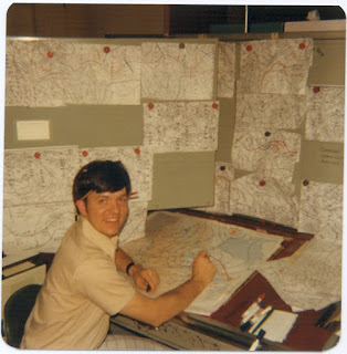
When the rotational speed of the vortex equals the speed of translation, a calm wind is created on the north (top of the earth frame purple graphic above) side of the cyclonic rotation. What meteorologists analyse as a low pressure centre is about to be created on the surface map in the earth frame of reference. A further decrease in the speed of translation must produce an east wind in the earth frame. This east wind invites every meteorologist to analyse a low pressure centre in the earth frame immediately to the south of that wind. You can tell from this 1977 image of a very keen and young meteorologist, that I loved finding those easterly winds and lows.
When the pure rotation stops moving in the earth frame as depicted in the above graphic, the
rotation we see in the atmospheric frame is identical to what we see in the
earth frame. That upper trough transforms to a cut-off low when the translation
of the rotational centre stops.
I hope you are still with me. I started presenting this
material in the early eighties and have lost mostly everyone at one point or another.
I have tried describing this process in many different ways hoping that one of
the methods will form a connection. Once you get it, you will have it for life.
The impacts of that rotation on cloud shapes will surprise you... but that is for the next day.
Thank you for getting this far...


1 comment:
I’ve been clicking around your blog posts, feeding new terms into my brain spaces. Does the term "pure cyclonic rotation in the atmospheric frame of reference " refer to the earth's rotation? And do most of these posts refer to storms…as opposed to calm? Some pretty crazy and exciting skies today on the Niagara Frontier and I am beginning to understand some of the shapes better due to your lessons.
I’ve always been a cloud watcher. We had them all today, from dark bottomed deep and tall fluffy cumulus to cirrus to wispy to solid gray walls of cold that sent me home.
Kath
Post a Comment