 |
| #2047 "New Beginning Sunrise" Pixels Link |
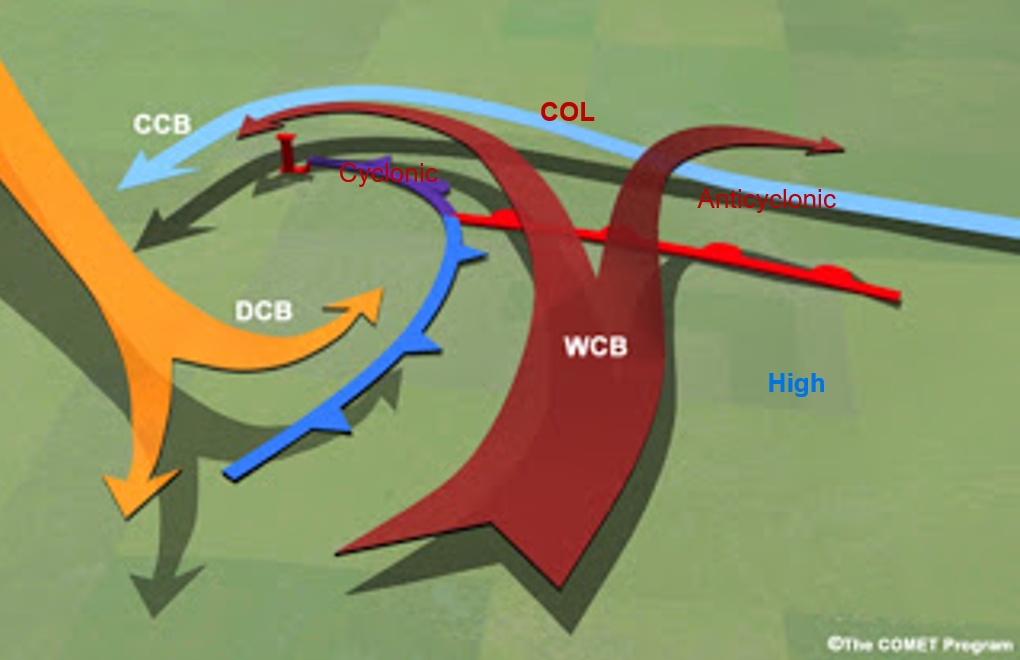
The conveyor belt conceptual model of the wind patterns found with a mid-latitude low pressure area, is fundamental to the understanding of cloud patterns. Note that the term “cyclone” is frequently used to replace “low pressure area”. The idealized conveyor belts are in the atmospheric frame of reference relative to the low.
 |
| The Conveyor Belt Conceptual Model |
 |
| Descending Smoke Ring to Croquet Hoop Analogy |

 The katabatic or inactive portion of the cold front is typically associated with the anticyclonic branch. The warm air above any katabatic cold front is actually descending. Any cloud associated with a katabatic front tends to be well ahead of the surface wind shift and cold front.
The cyclonic branch does not descend as far and tends to wrap around the cyclonic circulation which is the low pressure area for the mid-latitude storm. The anabatic or active portion of the cold front is typically associated with the cyclonic branch. The warm air any anabatic cold front is ascending and thus promoting the development of cloud and precipitation – most of which occurs behind the surface wind shift and cold front.
The col in the bow of the DCB deformation zone separate the weather regimes and the anabatic and katabatic portions of the cold front.
 |
| The Water Vapour from June 1st 2020 The area of thew DCB is clear on the corresponding visible imagery |
 Flows in the atmosphere are rarely as smooth as flowchart arrows. The dry conveyor belt (DCB) tends to be segmented into pulses associated with local wind maxima that move along the jet stream axis and energize the cyclone. These are called jet streaks and they will be another subject for a blog entry – jet streaks are that important too. This cross section is perpendicular to the WCB flow and shows how multiple DCB bursts might interact. Secondary lines of cloud can be expected where these DCB pulses collide with the cyclonic companion of the warm conveyor belt. Water vapour imagery is essential to analyzing these DCB pulses. Each pulse will bring a burst of stronger winds toward the ground.
Every line in the water vapour imagery has a story to tell and the conceptual models are your keys to unlocking and understanding the wonder of weather. Meteorologists typically analyze the first pulse of dry air. The other pulses are invisible without the aid of the WV imagery. The movement of dry air is every bit as important as the circulations of clouds.
Here is a weather information site created and maintained by my friends in Boulder, Colorado. I think you will find it very useful.
http://weather.rap.ucar.edu/satellite/ and select Water Vapor (mid)
That's enough for today... much more to come.
Warmest regards and keep your paddle in the water,
Phil the Forecaster Chadwick
1 comment:
Hi Phil,
Nice post as always
Just a bit of proofreading: The dry air is relatively <(???)> to start with and becomes drier and warmer as it descends.
Best
Yves
Post a Comment