 |
| #2564 "Singleton Sunday Thanksgiving Sunset" 8x10 |
One of the most important lessons in life and particularly for a meteorologist, is to keep an open mind. New facts and contributions from the fireside chat discussion might contribute to your analysis and diagnosis. More and better facts can lead to a better prediction. Missing information in this sunset sky is an example of how you could be mislead.
As per my sunset ritual, I watched a patch of overhead altocumulus drifting southeastward. Meanwhile the atmospheric frame relative winds were southwesterly as revealed by the distinctive wind gravity waves within that cloud. Wind waves in the atmosphere are shorter wavelength with less amplitude as compared to atmospheric swells. The sky was clear to the horizon and the setting sun. "Orange sky at night, sailor's delight". The saying calls for a "red" sky but the meaning is the same. The atmosphere was dry as far as I could paint and the saying predicted a cloud free and precipitation free day to follow. I was troubled by the angle that the wind waves made with that sharp cloud edge and wondered why...
 |
| Water Vapour imagery corresponding to the Singleton Thanksgiving sunset of #2564 |
 |
| Satellite Overview of the Cyclonic Companion (left) and the Anticyclonic Companion (right) Separated by the Jet which is near the centre of the Warm Conveyor Belt |
 |
| Closer View of the Anticyclonic Companion with the Cloud Enhanced in the Swell and Wind Wave Crests Looking Downward from the Satellite View An Example of Constructive Interference |
 |
| Conceptual Model Compared to the Water Vapour View - A Match (Close Counts in Meteorology) |
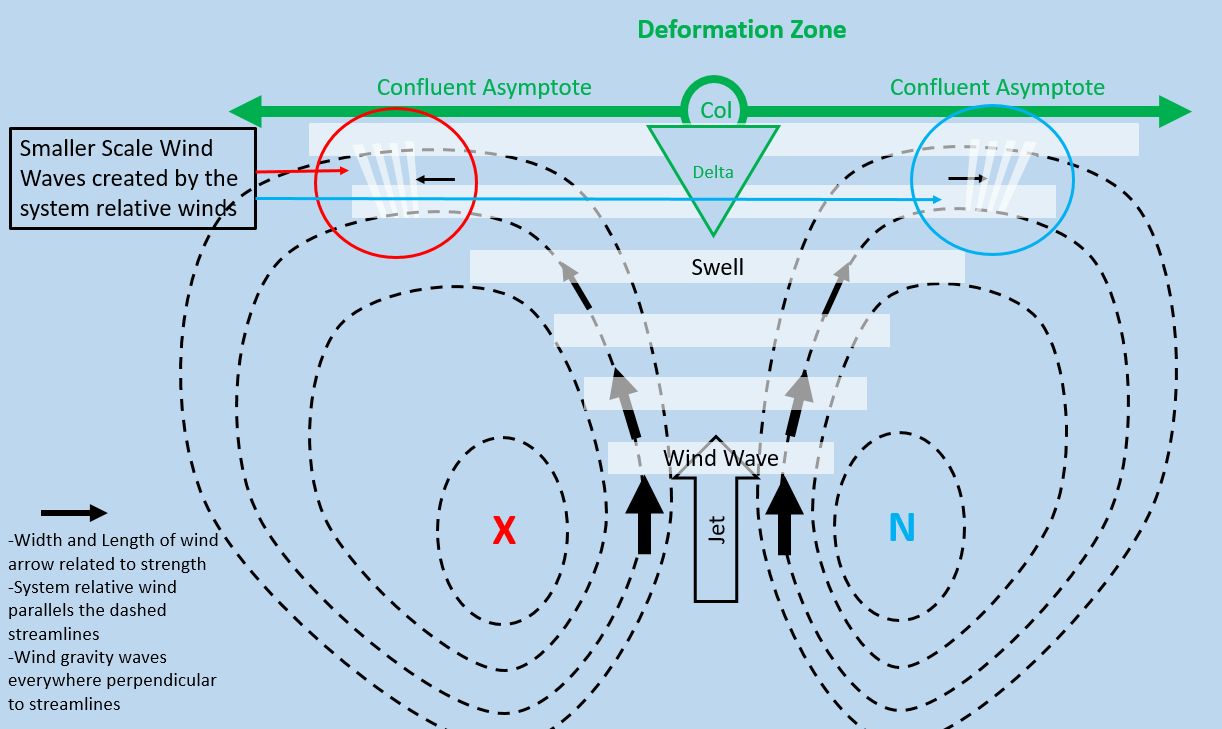
The portion of the conceptual model that is displayed in any given weather situation is dependent on the relative amplitudes of the swell and wind gravity waves and the lifted condensation level of the atmosphere. The circulations are always present but without water vapour or condensed cloud droplets, they are invisible.
The following graphic places the Singleton view of the small portion of the deformation zone within the larger scale Conveyor Belt Conceptual Model.
 |
| The Three (Four) Dimensional Atmosphere can be a Challenge to Interpret - Even for the Experts |
To recap: The patch of moisture that I painted was drifting southeastward as part of the anticyclonic companion flow of the conveyor belt conceptual model. This pattern is typical given our location in eastern Ontario (the yellow star in the graphic) and the fact that most emergent weather systems approach from Colorado or the Gulf of Mexico. Singleton typically sees the anticyclonic companion of the approaching storm first.
The sharp back cloud edge that I painted was the western edge of the crest of an atmospheric ocean swell. The enhanced bands within that swell crest were wind wave crests in the anticyclonic flow. The fact that the wind crests made an angle with the swell edge revealed that there were two different processes at work. Dynamic forces in the atmosphere create the weather that we enjoy and the approaching conditions were not fair.
Note that the double cyclonic DZ in the above analysis is entirely within the upper trough while the bowed DZ stretches from the upper trough to the downstream ridge that is east of Singleton. Also note that there is more cloud (upward vertical velocity) associated with the cyclonic companion of the conceptual model than the anticyclonic branch. That is enough information for now - no need to go down the satellite detail, rabbit hole even if there is so much more to see and understand ... One satellite image could keep me busy for hours...
With these new pieces of data, one must amend the Biblical forecast for the following day from "fair- sunny with no rain" to "cloudy with rain"... This is a actual example of a specific weather situation and a real painting. I was thinking "red sky at night" when I did that art although I was troubled by that angle of the wind waves. The take home message is that nature is always right. Our interpretation could be faulty if we do not listen to all of the facts.
 |
| #2564 "Singleton Sunday Thanksgiving Sunset" In Progress - Starting tithe the meteorology |
The clouds always tell the truth even if humans might not fully understand. I paint what I see and nature always makes sense even if it might take some effort to unravel those lines in the sky.
Keep you paddle in the water and warmest regards...
Phil the Forecaster Chadwick
No comments:
Post a Comment